
11/3/14
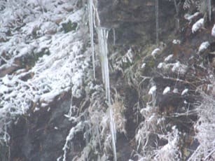
Icicles on Richard Russel Scenic Highway Saturday Photo by: Bill Kinsland
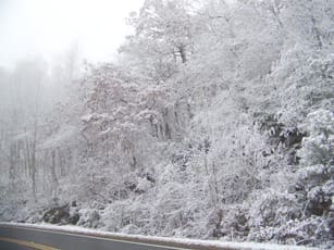
Snow and Ice cover at J.M. Davidson overlook on Richard Russel Scenic Highway Saturday. Photo by: Bill Kinsland
(Sautee)- You may not have seen the snow Friday night and Saturday morning in White County but there was some areas in the northern part of the county that a trace or a light dusting of snow was observed.
WRWH weather reporter Bill Kinsland has done some checking of weather records and found out that Saturday’s recorded snow was definitely the earliest we have ever recorded any snow.
According to Bill the next earliest date was November 12, 1968. On that date Cleveland National Weather Service Observer Mary Lou Sutton measured 8/10 of an inch and Helen Observer C.L. Vandiver measured 3/10 of an inch.
Bill check out the winter conditions Saturday at the mountain top on Richard Russel Scenic Highway. Below is Bills report of the cold and snow:
Suddenly a major shift in the jet stream slammed a massive cold front into the North Georgia Mountains Friday, colliding with moisture from the Gulf of Mexico. Temperatures plunged Friday afternoon and evening at all three official weather stations in White County as snow began to fall in Tennessee and North Carolina. By 3 AM Saturday, snow was falling across the northernmost Georgia counties and all across the upper elevations of the Blue Ridge Divide.
By Saturday noon, a thin blanket of snow covered most elevations above 2,000 feet in White County….enough to give the appearance of the proverbial ‘winter wonderland’. Fortunately most highway surfaces through the upper mountain passes remained warm enough to be free of frozen hazards.
A Saturday-afternoon excursion along Richard Russell Scenic Highway revealed a fascinating weather picture. Up to Milepost 3 (at an elevation of 2117 feet), there was little evidence of frozen precipitation. However by the time, Milepost 4 was reached, pockets of snow were seen on the nearby forest floor. Winds picked up quickly, making travel of high-profile vehicles quite challenging.
Pulling into J.M. Davison Overlook at an elevation of 3350 feet between Mileposts 6 and 7, the landscape was pure white. Snow accumulations of one-half to one inch were measured in open areas. Snow weighed heavily on tree branches and icicles hung like Christmas ornaments from every rocky ledge. The winds were measured at 15 to 20 mph, gusting to as high as 35 mph straight out of the north. The temperature was 30 degrees…producing wind chills of 14 to 19 degrees.
According to the National Weather Service, this cold blast will be short lived. Already temperatures were beginning to warm by Sunday noon. Temperatures through this coming weekend are expected to range from lows in the upper 30’s to highs approaching 70 degrees.


